
Bear Cave Trail
- The Basics
- Type: Hiking
- Length: ¼ mile
- Difficulty: Easy
- Time: ½ hour
- Requirements: None
- Description
- Although there is no true cave, visitors along this trail can explore huge sandstone boulders and shelters. Many form narrow passage ways that can be walked on, over, through, and around. Just think what tremendous natural forces took place to sculpt these gigantic formations!
- Additional Info
- Camping: No
- Water: No water on trail
- Trail Head(s):
- Trail Markings: Light Pink Blazes
- Pets Allowed:
- Recommended Season:
Boy Scout Trail
- The Basics
- Type: Hiking
- Length: 12 miles Loop
- Difficulty: Moderate - Strenuous
- Time: 6+ hours
- Requirements: Register at visitors center if planning to hike entire trail
- Description
- Connected to or following almost all the other trails within the park, the Boy Scout trail is long and in some places difficult. All of the park's different ecosystems and habitats are represented along this trail, including the canyon rim and the Cedar Falls area. Please allow extra time for breaks, and bring plenty of water. Shorter hikes can be made, as this trail connects to many other trail heads in the park.
- Additional Info
- Camping: No
- Water: No water on trail
- Trail Head(s): Davies Bridge/CCC Bridge over Cedar Creek
- Trail Markings: White Blazes
- Pets Allowed:
- Recommended Season:
Canyon Trail
- The Basics
- Type: Hiking
- Length: 1 mile One-Way; 2 mile Loop
- Difficulty: Easy
- Time: 1 - 2 hours
- Requirements: None
- Description
- One of the park's most beautiful trails, Canyon Trail is also one of the least hiked trails at the park. Beginning after you cross the bridge on Cedar Falls Trail, hikers need to head left instead of right and follow the yellow blazes to Blue Hole. Here the trail decends into the canyon along side Cedar Creek. Many large boulders and tall pines and sycamores dot the trail's scenery. After about a mile, you will reach Blue Hole, which is the old swimming hole that was used by the CCC during the 1930's as they constructed many of the park's features. Blue Hole is the end of the trail; You can either return back the same way, or hike a section of the Boy Scout Trail to complete a loop. The Boy Scout Trail intersects the Canyon trail at Blue Hole.
- Additional Info
- Camping: No
- Water: No water on trail
- Trail Head(s): Mather Lodge
- Trail Markings: Yellow Blazes
- Pets Allowed:
- Recommended Season:
Cedar Creek Trail
- The Basics
- Type: Hiking
- Length: 1¼ miles Loop
- Difficulty: Moderate
- Time: 1 hour
- Requirements: None
- Description
- Constructed by the Civilian Conservation Corps in the 1930's, this trail travels a scenic section of Cedar Creek above the falls. Steep bluffs and uneven rock steps make some parts of this trail slightly difficult. A pioneer cabin is also located along the trail. Trail guides are available at the visitors center and Mather Lodge.
- Additional Info
- Camping: No
- Water: No water on trail
- Trail Head(s):
- Trail Markings: Dark Pink Blazes
- Pets Allowed:
- Recommended Season:
Cedar Falls Trail
- The Basics
- Type: Hiking
- Length: 2¼ miles Loop
- Difficulty: Moderate
- Time: 1½ - 2½ hours
- Requirements: None
- Description
- At just over 2 miles round trip, Cedar Falls Trail takes you to the park's main feature, 95-foot Cedar Falls. Beginning behind the breezeway at Mather Lodge, this trail quickly decends into Cedar Canyon. Along the trail, a small spring creates many small waterfalls as it cascades beside the trail. After you reach the canyon floor, the trail follows Cedar Creek for about ½ mile, reaching the falls after a dramatic turn in the trail that hides the falls untill you are right there! Allow plenty of time for this hike, as it is all uphill on the way out.
- Additional Info
- Camping: No
- Water: No water on trail
- Trail Head(s): Behind Mather Lodge
- Trail Markings: Orange Blazes
- Pets Allowed:
- Recommended Season:
Rock House Cave Trail
- The Basics
- Type: Hiking
- Length: ¼ mile One Way
- Difficulty: Easy
- Time: ½ hour
- Requirements: None
- Description
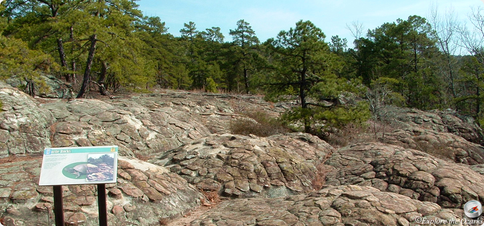
- Rock House is not actually a true cave, but rather a large rock shelter in the side of a bluff. It is, however, one of the premiere places in the state to view indian rock paintings, created over 500 years ago. Nearby, the trail also leads to some of the most unique rock formations in the park, Turtle Rocks. Take time to explore and study these formations.
- Additional Info
- Camping: No
- Water: No water on trail
- Trail Head(s):
- Trail Markings: Purple Blazes
- Pets Allowed:
- Recommended Season:
Seven Hollows Trail
- The Basics
- Type: Hiking
- Length: 4½ miles Loop
- Difficulty: Moderate
- Time: 2 - 4 hours
- Requirements: None
- Description
- Located on the west end of the park, Seven Hollows Trail has something to offer for everyone. The first ½ mile or so winds through dense, short vegetation, a result of a forest fire during the summer of 2000. You soon drop out of the burned area into the many hollows this trail is named for. After about 1¼ miles, you come upon the first natural featue highlight, a natural bridge, or arch.
Further down the trail, at about the halfway point, is the Grotto. A small side spur leads into the Grotto, which is a box canyon with a small waterfall and pool at the end. Look for animal tracks in the mud at the pool! Many other natural features, including bluffs and rock shelters can be found along the rest of the trail.
- Additional Info
- Camping: No
- Water: No water on trail
- Trail Head(s): ½ mile west of Mather Lodge on Ark Hwy 154
- Trail Markings: Light Blue Blazes
- Pets Allowed:
- Recommended Season: