
Bear Hollow Trail
- The Basics
- Type: Hiking
- Length: 2.8 miles One-Way
- Difficulty: Moderate
- Time: 1½ - 3 hours
- Requirements: None
- Description
- The Bear Hollow Trail follows along the upper rim of Bear Hollow, traveling from the Benefield Picnic Area to Hwy 309 just below the horse camp. There are many points of interest along the trail, including Sunrise Rock, Inspiration Point, Bear Head Bluff, and Shoal Creek. Some the most scenic views can be found along this trail. Many wet-weather creek crossings lead to beautiful waterfalls during rainy seasons.
- The trail also gives hikers the option of starting at the picnic area or near the visitor center, creating a 7.5 mile loop connecting to four other trails. For those wanting to make a shorter loop, a spur trail reconnects with the Benefield West Loop Trail, marked by orange blazes.
- Additional Info
- Camping: No
- Water: No water on trail
- Trail Head(s): Benefield Picnic Area
- Trail Markings:
- Pets Allowed:
- Recommended Season:
Benefield Loop Trails - East Loop
- The Basics
- Type: Hiking
- Length: 1.1 miles Loop
- Difficulty: Easy
- Time: ½ hour - 1 hour
- Requirements: None
- Description
- The Benefield Trail consists of two loops, an East Loop and a West Loop, totaling 2 miles in length. Each loop begins in the Benefield Picnic Area. Scenic beauty, wildflowers, and history are prominent features found along these loops.
- The East Loop follows along a path that was originally constructed by the Works Progress Administration (WPA) in 1938. The trail offers great views into Bear Hollow, old stone fences, and across the highway near the Petit Jean River Valley Overlook. From here it follows a bluff line below the highway to stone steps leading back to the picnic area. This loop is 1.1 miles long.
- Additional Info
- Camping: No
- Water: No water on trail
- Trail Head(s): Benefield Picnic Area
- Trail Markings:
- Pets Allowed:
- Recommended Season:
Benefield Loop Trails - West Loop
- The Basics
- Type: Hiking
- Length: 0.9 miles Loop
- Difficulty: Easy
- Time: ½ hour - 1 hour
- Requirements: None
- Description
- The Benefield Trail consists of two loops, an East Loop and a West Loop, totaling 2 miles in length. Each loop begins in the Benefield Picnic Area. Scenic beauty, wildflowers, and history are prominent features found along these loops.
- The West Loop leads across the road to a wildlife pond. From here it connects with the Mossback Ridge Trail, which is blazed in yellow. The trail then returns back here via the entrance road to the picnic area, passing a grave. White-tailed deer and black bear are commonly seen along this trail. This loop is 0.9 miles long.
- Additional Info
- Camping: No
- Water: No water on trail
- Trail Head(s): Benefield Picnic Area
- Trail Markings: Blue Blazes
- Pets Allowed:
- Recommended Season:
Greenfield Trail
- The Basics
- Type: Hiking
- Length: 0.9 miles One-Way
- Difficulty: Moderate
- Time: ½ hour - 1 hour
- Requirements: None
- Description
- Before the Great Depression, a family farm sat where what is now the Greenfield Picnic Area and the visitor center. This trail gets its name from that family. The Greenfield Trail starts in the picnic area, crosses the headwaters of Big Shoal Creek, and meets up with the Mossback Ridge Trail. Its elevation gain is just over 200 feet. This trail makes a great starting point for a 14-mile hike to Cove Lake.
- Additional Info
- Camping: No
- Water: No water on trail
- Trail Head(s): Greenfield Picnic Area
- Trail Markings: Green Blazes
- Pets Allowed:
- Recommended Season:
Huckleberry Mountain Multi-Use Trail
- The Basics
- Type: Hiking, Backpacking, Mtn Biking, Equestrian, ATV
- Length: 0.6 - 34.3 miles
- Difficulty: Moderate - Strenuous
- Time: ½ hour - Overnight
- Requirements: None
- Description
- The only multi-use trail within the state park, only the first 0.6 miles are within the parks boundaries. Horses and motorized vehicles are not allowed on any other trail in the park. Starting in the horse camp area, this trail follows an old wagon trail, dropping over 200 feet down to the highway. From there it travels into the National Forest. The trail is divided into two loops; the Huckleberry Mountain Loop, and the Apple Loop. The Huckleberry Mountain loop is 22.4 miles in length, while the Apple Loop is 11.9 miles in length. For more details, pick up the Huckleberry Mountain Horse Trail brochure at the visitors center.
- Additional Info
- Camping: Not allowed within park boundaries; Allowed within the national forest.
- Water: No water on trail
- Trail Head(s): Mount Magazine Horse Camp
- Trail Markings: Huckleberry Mtn Loop: Orange Blazes
Apple Loop: Yellow Blazes - Pets Allowed:
- Recommended Season:
Mossback Ridge Trail
- The Basics
- Type: Hiking
- Length: 2.1 miles One-Way
- Difficulty: Moderate
- Time: 1 - 2 hours
- Requirements: None
- Description
- The Mossback Ridge trail is named after Albert Morsbach, a settler, farmer, and teacher from the area. The trail connects four other trails: Benefield West Loop, Greenfield, North Rim, and Signal Hill. Most of the trail is easy walking upon a ridge top. Many wildflowers can be seen, as well as signs of bears moving rocks and logs.
- Additional Info
- Camping: No
- Water: No water on trail
- Trail Head(s): Connecting trail accessible from four other trails
- Trail Markings: Yellow Blazes
- Pets Allowed:
- Recommended Season:
Mt. Magazine-Cove Lake Trail
- The Basics
- Type: Hiking, Backpacking
- Length: ½ mile - 9.7 miles One-Way
- Difficulty: Moderate - Strenuous
- Time: ½ hour - Overnight
- Requirements: None
- Description
- At 9.7 miles in total length, only the first .5 mile is located within the park's boundaries. Starting at the Cameron Bluff Campground, this trail decends its way down to Cove Lake, dropping over 1,500 feet in elevation along the way. The trail can be hiked in one day, but is best enjoyed as an overnight backpacking trip. Camping is allowed outside of Mount Magazine State Park as it travels through the National Forest. The Forest Service Recreation Area at Cove Lake also offers camping, as well as picnicking and swimming.
- Additional Info
- Camping: No
- Water: No water on trail
- Trail Head(s): Cameron Bluff Campground
- Trail Markings: White Diamond Blazes
- Pets Allowed:
- Recommended Season:
North Rim Trail
- The Basics
- Type: Hiking
- Length: 2.2 miles One-Way
- Difficulty: Moderate
- Time: 1½ - 2½ hours
- Requirements: None
- Description
- Starting near the visitor center, the North Rim Trail follows along the north rim of the mountain to Cameron Bluff Overlook Drive. The trail passes through hardwood oak forests, cedar glades, and crosses many wet-weather streams. Bluffs along the trail offer views of the Arkansas River Valley and the Ozark Plateau. A spur to this trail leads to the western end of Mossback trail, providing a 4.4 mile loop back towards the visitor center.
- Additional Info
- Camping: No
- Water: No water on trail
- Trail Head(s): Just west of Visitor Center
- Trail Markings: Red Blazes
- Pets Allowed:
- Recommended Season:
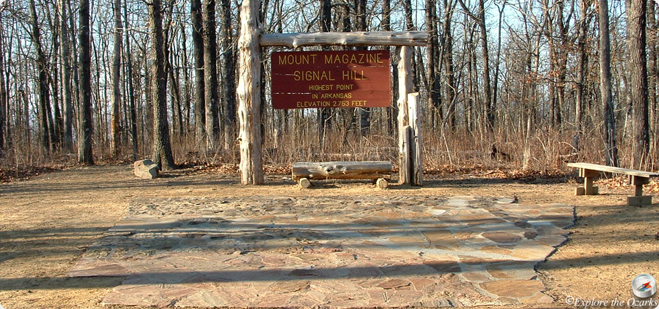
Signal Hill Trail
- The Basics
- Type: Hiking
- Length: 1½ miles
- Difficulty: Moderate
- Time: 1 hour
- Requirements: None
- Description
- With an elevation of 2,753 feet, Signal Hill is the highest point in Arkansas. No visit to Mount Magazine should end without hiking to the highpoint. At the top of the mountain is a 400 square foot stone map of arkansas. This well-maintained trail also serves as a connecting trail from Cameron Bluff Campground to the Mossback Ridge Trail and The Lodge at Mount Magazine.
- Additional Info
- Camping: No
- Water: No water on trail
- Trail Head(s): Near Cameron Bluff Campground
- Trail Markings:
- Pets Allowed:
- Recommended Season:
Will Apple's Road Trail
- The Basics
- Type: Hiking, Mountain Biking
- Length: 1.6 miles
- Difficulty: Easy
- Time: 1 - 1½ hours
- Requirements: None
- Description
- Named for a local farmer who once lived on the mountain, Will Apple's Road Trail was the first road constructed to the top of Mount Magazine. During the 1800s, wagons used this road to haul produce to the valley below. The trail starts just east of the visitors center, and works its way towards the horse camp. Highlights along the trail include wildflowers, woodland songbirds, stone fences, historic homesites, and the ruins of a swimming pool built in the 1920s. Mountain bikes are allowed on this trail.
- Additional Info
- Camping: No
- Water: No water on trail
- Trail Head(s): Near Visitor Center
- Trail Markings:
- Pets Allowed:
- Recommended Season: