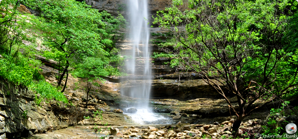
Waterfalls
As simple as water flowing over a ledge, waterfalls are very awe-inspiring and spectacular. Something that fascinates just about everyone, they are sought after jems hidden in nature. While some are as easily found as walking 10 feet from your car, many are also hidden deep in the forest down lengthy trails, or not even near a trail at all. Wherever the location, the destination is always worth the journey when it comes to finding a waterfall.
*Currently, there are so many more waterfalls within the Ozarks and Ouachitas than I have had time to photograph, gather information for, and list here. As soon as new information becomes available, and I am able to gather pictures, I will post those new waterfalls here.*
If you own or manage a business or service near a large waterfall, and would like to advertise here, please contact me at advertising@exploretheozarksonline.com
| Waterfall | Height | Distance* | Difficulty | Location | Region |
|---|---|---|---|---|---|
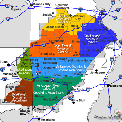
| Amber Falls Go | 018' | 0.35 miles | Moderate Bushwack | Upper Buffalo Wilderness (USFS) | Arkansas Ozarks & Boston Mtns |
| Bowers Hollow Falls Go | 056' | 2.0 miles | Strenuous Bushwack | Upper Buffalo Wilderness (USFS) | Arkansas Ozarks & Boston Mtns |
| Cedar Falls Go | 095' | 1 mile | Moderate Hike | Petit Jean State Park | Arkansas River Valley & Ouachita Mtns |
| China Falls Go | 068' | 0.25 miles | Easy Bushwack | Ozark National Forest | Arkansas Ozarks & Boston Mtns |
| Compton's Double Falls Go | 039' | 1 mile | Moderate Bushwack | Upper Buffalo Wilderness (USFS) | Arkansas Ozarks & Boston Mtns |
| Cossatot Falls Go | 0' (cascades) | 0.25 miles+ | Easy Hike | Cossatot River State Park | Arkansas River Valley & Ouachita Mtns |
| Cougar Falls Go | 077' | 0.3 miles | Easy Bushwack | Ozark National Forest | Arkansas Ozarks & Boston Mtns |
| Crooked Creek Falls Go | 016' | 0' (View from car) | Easy | Ouachita National Forest | Arkansas River Valley & Ouachita Mtns |
| Crosscut Falls Go | 053' | 0.3 miles | Easy Bushwack | Ozark National Forest | Arkansas Ozarks & Boston Mtns |
| Dogwood Falls Go | 037' | 0.6 mile | Moderate Bushwack | Ozark National Forest | Arkansas Ozarks & Boston Mtns |
| Dripping Springs Falls Go | 077' | 0.5 mile Loop | Easy Hike | Natural Falls State Park | Oklahoma Ozarks |
| Falling Spring Falls Go | 013' | 0' (View from car) | Easy | Mark Twain National Forest | Southeast Missouri Ozarks |
| Falling Water Falls Go | 010' | 0' (View from car) | Easy | Ozark National Forest | Arkansas Ozarks & Boston Mtns |
| Falls Creek Falls Go | 012' | 0.7 miles | Easy Hike | Lake Catherine State Park | Arkansas River Valley & Ouachita Mtns |
| Forked Mountain Falls Go | 010' | 0.8 miles | Easy Hike | Ouachita National Forest | Arkansas River Valley & Ouachita Mtns |
| Glory Hole Go | 031' | 1 mile | Moderate Hike | Ozark National Forest | Arkansas Ozarks & Boston Mtns |
| Haley Falls (2) Go | 017' / 045' | 1.1 miles | Moderate Hike | Upper Buffalo Wilderness (USFS) | Arkansas Ozarks & Boston Mtns |
| Hamilton Falls Go | 012' | 2.3 miles | Moderate/Strenuous Bushwack | Richland Creek Wilderness | Arkansas Ozarks & Boston Mtns |
| Hardy Falls Go | 008' | 0' (View from car) | Easy | Ozark National Forest | Arkansas River Valley & Ouachita Mtns |
| Haw Creek Falls Go | 008' | 0.02 miles (100') | Easy | Ozark National Forest | Arkansas Ozarks & Boston Mtns |
| High Bank Twins Go | 071' | 0.25 miles | Easy Bushwack | Ozark National Forest | Arkansas Ozarks & Boston Mtns |
| Hobo Falls (2) Go | 023' / 027' | 1.5 miles | Moderate Hike | Ozark National Forest | Arkansas Ozarks & Boston Mtns |
| Hudson Shelter Falls Go | 024' | 0.4 miles | Easy Bushwack | Ozark National Forest | Arkansas Ozarks & Boston Mtns |
| Kings Bluff Falls Go | 114' | 1.9 mile Loop | Easy Hike | Ozark National Forest | Arkansas Ozarks & Boston Mtns |
| Lichen Falls Go | 028' | 0.25 miles | Easy Hike | Ozark National Forest | Arkansas Ozarks & Boston Mtns |
| Little Glory Hole Go | 018' | 0.3 miles | Easy Bushwack | Ozark National Forest | Arkansas Ozarks & Boston Mtns |
| Little Missouri Falls Go | 0' (Cascades) | 0.25 miles | Easy Hike | Ouachita National Forest | Arkansas River Valley & Ouachita Mtns |
| Mt. Magazine Cascade Go | 100'+ | 0.5 mile | Easy Hike | Mt. Magazine State Park | Arkansas River Valley & Ouachita Mtns |
| Mt. Magazine Falls Go | 028' | 0.35 mile | Moderate Bushwack | Mt. Magazine State Park | Arkansas River Valley & Ouachita Mtns |
| Mt. Nebo Falls Go | 032' | 0.06 miles (100yds) | Easy Hike | Mt. Nebo State Park | Arkansas River Valley & Ouachita Mtns |
| Mule Trail Falls Go | 031' | 2.2 mile Loop | Moderate Hike/Bushwack | Upper Buffalo Wilderness (USFS) | Arkansas Ozarks & Boston Mtns |
| Murray Falls Go | 037' | 0.5 mile | Moderate Bushwack | Ozark National Forest | Arkansas Ozarks & Boston Mtns |
| Natural Dam Go | 008' x 187' | 0' (View from car) | Easy | Ozark National Forest | Arkansas Ozarks & Boston Mtns |
| Pack Rat Falls Go | 024' | 0.3 miles | Moderate Bushwack | Ozark National Forest | Arkansas Ozarks & Boston Mtns |
| Pam's Grotto Go | 037' | 0.5 miles | Moderate Hike/Bushwack | Ozark National Forest | Arkansas Ozarks & Boston Mtns |
| Richland Falls Go | 008' | 3.3 miles | Strenuous Bushwack | Richland Creek Wilderness | Arkansas Ozarks & Boston Mtns |
| Senyard Falls Go | 029' | 0.5 mile | Moderate Bushwack | Ozark National Forest | Arkansas Ozarks & Boston Mtns |
| Six Finger Falls Go | 006' | 0.02 miles (100') | Easy | Richland Creek Wilderness | Arkansas Ozarks & Boston Mtns |
| Thousand Kisses Falls Go | 048' | 2.2 mile Loop | Moderate Hike/Bushwack | Upper Buffalo Wilderness (USFS) | Arkansas Ozarks & Boston Mtns |
| Twin Falls of Devil's Den Go | 047' / 056' | 1.5 mile Loop | Easy Hike | Devil's Den State Park | Arkansas Ozarks & Boston Mtns |
| Twin Falls of Richland Creek Go | 017' / 019' | 2.8 miles | Strenuous Bushwack | Richland Creek Wilderness | Arkansas Ozarks & Boston Mtns |
*All distances are one-way, unless otherwise noted*